Return to Home Page,
Return to Nike Location index
go to previous,
go to top,
go to next
Locations of Former NIKE MISSILE SITES (text)
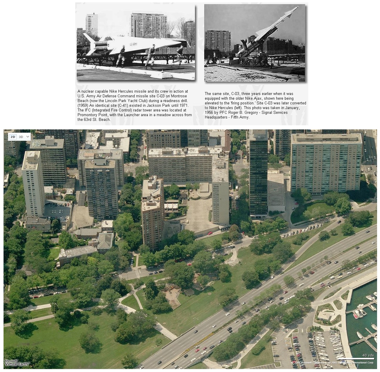
C-03
(double) | Montrose/Belmont
| C - Montrose Wilson Beach, end of Montrose Ave ((O) Lincoln Park;
Montrose Wilson Beach
[{Page, T} April 2007 location photos 500 KBytes
"Both views are looking ~ due west. In the modern-day (color) photo, the tell-tale apartment building is in the
upper-right corner. I think we already have this site's location nailed ... but these side-by-side images should
help to further pin-point the site of the Montrose Nike Missile Launch Battery, C-03L. The actual launch strips
were east of the main N-S highway (and thus out of the color image)." ]
[{Jankowski, A} (2001) Same as launch area. Area
completely redeveloped. Old USTs recently removed. ]
L - Montrose Wilson Beach, end of Belmont St ((O) Lincoln Park; yacht club)
Location verified by Corey J. Motel
[{Jankowski, A} (2001) All above-ground structures razed.
Not certain if magazines were filled in, but there's no evidence of them on surface.
Area completely redeveloped. ]
|
| C-40 | Burnham Park,
|
a Mark Morgan trip report
C - Lake Shore Dr & 31th St (Burnham Park)
L - Lake Shore Dr & 31th St (Burnham Park) |
| C-41 | Jackson Park,
web site
local copy
another web site
- (down a little way)
-Jackson Park, Chicago
-1962 - 1965
|
C - Lake Shore Dr & 55th St ((O)Jackson Park)
A local web site that has some great images and odd viewpoints.
We (1955-1957) never heard of "mass protest marches" (or any protests other than rumored voiced before land acquisition
in the early 1950s) and I would rather expect to find bacteria in drains - duh -
And you certainly never had to be "intrepid" to photograph the outside of a Nike fence. - but that is Chicago for you -
[{Thelen, E}
GPS = 41N 47' 45", 87W 34' 33"
]
L - Lake Shore Dr & 63th St ((O)Jackson Park)
[{Thelen, E}
GPS = 41N 46' 54", 87W 34' 36"
]
|
IFC as Hercules.
from Tomas Pepper
|
|
C-44
(double) | Hegewisch/Wolf Lake |
C - W of I 90, N of 136th St
[{Kurylowicz, C} (06/10) satellite pictures on Google Maps showing
1 radar tower standing and second lying on the side.In real world - both are gone.
Have been there this afternoon (06/03/2010), takin' pictures.Some building foundations have
also been removed lately. Sad site.]
[{Vaughn, T}The nearest street location is NNE
of Ave K & 133 Street. This area is within the state park and is located
right on the lake. One of the towers was sitting in the middle of a
creek. It is about a 3/4 mile hike in from where you park your car.
I found 4 radar towers, all of them concrete. 3 of
them were very tall and one shorter one.}
L - W of I 90, N of Wm. W Powers Conservation Area
[{Cymerman, M} (June 2017) A quadcopter YouTube view
https://youtu.be/sVBcFDOTfJE
[{Siegfried, W} (July 2012) Not a whole lot to add to the
previous posts. There is a nice memorial of an Ajax missile and a commemorative plaque
in the park that is worth checking out. There also is a substantial parking/picnic area
on the north side of the lake with a restroom that is just on the other side of the Launch
site. A short walk of 100 feet or so on a marked trail takes you right into the launch
area where you are welcome to walk around. All the elevators have been filled in and have
substantial trees growing out of them. Just foundations and some blast pads to see. The
size of the double site is very impressive. ]
[{Kurylowicz, C} (06/10) Some garbage have been removed last year. ]
[{Vaughn, T} The launch/admin area is
just north of the park Saki runs, which is a state operation. The site
is in a Cook County forest preserve.]
Calumet Ecological Park
[{Motel, C}"To get to this area, enter the William Powers Conservation Area
(off of Avenue O). Turn left at the first opportunity and take this road through the
parking lot and into the wooded area. The road will bend to the right, a rest area
will eventually be seen on the right, finally the road will bend to the left (at
which point the lake will be immediately to the right).
Follow this road (for about 300 - 500 feet) up to the small (space for only 2 or 3
cars) unpaved parking cove on the left. Pull in. If you get to the train tracks
you've gone too far.
You'll find the magazines about an eighth of a mile in front of your car.
The buildings appear to be gone, but sight of the six magazines is somewhat
impressive. They're arranged in two groups of three. In each, the three pits
are set end-to-end. The two groups are then set side-by-side. All that remain are
the steel blast plates. The elevator doors and personnel hatches have long since
been removed and back-filled with dirt."]
[{Murdock, S} GPS=41-40-35 87-31-41
] |
| C-50 | Homewood
| C - W of Il. 1, H of 187th St. ((P)IL ArNG recruiting
[{Burgess, P} (3/2002) ... . The ING abandoned
the site several years ago and it has only just been demolished and converted
into a public park. I am trying to get the local park district to erect a
plaque remembering the site, but so far no go. I am a US navy vet and thought
that the efforts of the Army here should at least warrant a plaque.
We'll see how it goes. ]
L - Il 1, S of 187th St ((P)Mercy Health Care/USAR Center) |
| C-51 | Worth/Palos
Heights/LaGrange
| C - S of I 294, W of Central Ave
[{Kurylowicz, K} July 2010 - It's located next to the Village
of Alsip boat ramp (West Plattner Drive, Alsip, Ill.).Very dense
underbrush.Two concrete radar towers still standing.One is nicely
visible.Second is not - covered by trees. I'havn't found any other buidings
or structures.Not even traces of 'em. ]
[{Motel, C}"... a radar tower is visible on the south
side of I-294 about one mile west of Cicero Ave. (Route 50).]
L - 1 W, S of I294
[{Berhow, M} (June 3, 2010) I got to visit the Worth C-51 nike site
last week, now State of Illinois DOT maintenance facility. RSS2 and RSS3 list the site as 2B/1C
or 3 magazines. The 1960 report list the Worth site as having only 2 magazines. Looking at the
site and the drawings from the state highway department for building the maintaince facility
that is there now shows only 2 magazines. The entry should be 2A magazines. Oh well. Both
magazines are visible, the southern one is part of the tarmac, the northern one has been filled
in with debris, but the launch pads are still there. The only building remaining is the missile
assembly building.
|
| C-54 | Orland Park
| C - SW Orland Park, S of 153d St
[{Welshans, T} Jan 2007 - Andrews Corporation owns the land where the control
center for the Orland Park Nike site was. They have used the buildings for storage until recently. All of the
buildings have been razed in December, 2006 as they are selling or have sold the property. ]
L - SE Orland Park, N of 159th St
[{Welshans, T} Jan 2007 - Orland Park and The USAR own the land where the launch site
was. The Army has a vehicle repair shop facing LaGrange Road that extends back to the village property. The "U"
shaped earth mound where missles were fueled is still visable with a building in the center. The area is a
village equipment repair center. ]
|
| C-61 | Lemont
| [{Shaffer, W} (May 2007) ... was the site of the nation's
first nuclear-tipped Hercules installation.
Capt. Robert Lindemann commanded the conversion activity at the site, securely located on the site of the
Atomic Energy Commission's Argonne National Laboratory. AEC and DOD inspections occurred almost daily.
The 22nd Arty Group commander, Col. Avery W. Masters, was on-site virtually every day, as well.
Transition was smooth and the site was operational on time and on-budget. Spring 1959 or thereabouts. ]
C - 91st St, E of Bailey Rd (Argonne National Laboratories)
[{Motel, C} The road is Cass Ave. not Bailey.
After turning east on 91st Street, four "service entrances" will be seen on the
right hand side. (This is the Waterfall Glen preserve which is part of the DuPage
County Forest Preserve District.)
Based on conversations with some local residents as well as a ranger at the forest
preserve district headquarters, the control site was somewhere between the second
and forth of these entrances. The second one has a locked gate and paved driveway.
Within is a small but conspicuous hill and signs of now removed perimeter fencing
in the back. Behind the third entrance are abandoned utility poles, while the forth
entrance is a paved roadway leading back to government housing for the site.]
[{Schueler, Bob}, Oct 2020 - ...
slowly deteriorated until only the two tracking towers were left and then those were
removed as well - probably late 80's as well. Today it's part of a Forest Preserve walking
trail with no evidence of its existence.]
L - SW corner, I55/Bailey Rd interchange (Argonne National Laboratories)
[{Schueler, Bob}, Oct 2020 -
There's an office building on the site now.]
[{Russel, G} (Mar 2012) My family lived less than a mile from the site
and in fact, we used to watch the army bring the missiles up every one or two weeks.
--Bailey road used to go through that area, it is now Cass Avenue.
--The missile site was at the Southwest corner of Cass and I-55.
--The barracks, radar and perhaps the control areas were just east of Cass on 91st.
[{Motel, C}Bailey doesn't extend south of I-55.
The directions are
actually Cass Ave. south from I-55 until the first right (a frontage road).
This frontage road leads to the old site. All traces of the launch site are gone.
It is now: Army Reserve Center, Argonne, Illinois]
|
| C-70 | Naperville
|
news story
link from Thomas Page
C - 2 SE Warrenville, S of Il 5 (AMOCO)
FUDS report for C-70 stored locally.
[{Page, T} (June 2007) The Control/Housing area of the property is located at N41�48�36�, W88�08�49�
[{Perro, W} (May 2007) The Launch Area is south of I-88 and on the south side of Diehl Road.
This area has both commercial development and a recreational park. The name of the park is "Nike Park"!
The Control Area is north of I-88 and south of Warrenville Road. The Control Area is owned by BP and is the subject of an
environmental cleanup. ]
[{Morin, C}The control site was south of I-88 at the corner
of Mill St. and Diehl Rd. The bunkers were filled in and the Naperville Park
District built several very nice baseball/softball fields on top of it and is
named...take a guess... "Nike Park".]
[{Jankowski, A} (2001) All buildings razed. Site
occupied by Amoco. ]
L - S of Warrenville Rd, N of Il 5 (AMOCO)
[{Page, T} (June 2007) Launch area is located at N41�47�55�, W88�09�01�.
[{Cunningham, J}The Chicago C-70 site is listed as being
on/along Il-5. The site
is indeed the
location of an AMACO office/research center. I used to live in that area and
drive by often. However, the highway designation changed about 10 years ago. I5
was changed to I88, as reclassifying it allowed them to change the speed limit
to 65 mph. ... .]
[{Jankowski, A} (2001) Office park located over
entire site. One office building uses one of the old magazines for records storage
and has done a real nice job of updating for their use. The magazine is actually
incorporated into the floor plan of the office building. You walk down the hall
of this modern office building, turn a corner, and walk down some primitive
looking concrete steps into the magazine. ]
|
| C-72 | Addison
|
A nice example of after use of an old Nike site
YouTube,
from C J Elonich
C - ((P)City of Addison)
[{Behr, E} Jan 2007 - N 41-55-21 W 88-01-47 (deg-min-sec)
I have a few pictures from 2001 at http://www.math.niu.edu/~behr/Towers/
(search for Addison)
[{Lockman, M} Nov 2006 control site 80 KByte,
The location is still a community park, but the last remaining building and derelict radar tower have fallen
into disrepair. The radar tower�s ladder has been sealed off with steel plates and chain link to prevent
anyone from climbing to the platform, but vandals have cut up the chain link and kicked in sheet metal panels
around the tower�s base. Much of the original fenceline remains. Site is bordered on all sides by industrial
parks (KDA distributor to the west, UPS hub to the east). Posts for what was probably the sign explaining
the site are visible near the baseball diamond, but the sign is gone. ]
[{Elonich, C J} March 2005
a nice picture, 56 K Bytes
[{Motel, C} Location - A long block north of Fullerton Ave.
on east side
of Route 53, just south of the KDA distributor.
The site is _not_ completely obliterated. It has been turned into a community park.
One building remains. I'm sure the village uses it for storage. Better yet however,
one of the three radar towers is still standing and is accessible to the public.
(Nice job Addison!)
Back in 1984, an Addison village history book was published. It offers a nice one
page treatment on the site. Additionally, the village historical society has a folder
full of holdings, however most are newspaper clippings which deal with vandalism
to the launch site.]
L - E of Lombard, S of Fullerton ((O)Addison Dept. of Public Works
[{Motel, C}Unfortunately, new public works construction
is underway, and all
traces of the launch facility are gone. (Except for the original perimeter fencing,
a government property sign, and a blue-print in the construction trailer showing what
must have been old concrete placements upon the site.)]
Housing:
Remote Housing:
|
| C-80 | Arlington Hts.
|
C -N side Algonquin & Golf Rd; ((o) park/mini-mall)
[{Lockman, M} Jan 2007 -
What I have been able to compile from several sources is a brief history of the C-80 control site which you may find interesting:
--The original location was more than three times its current size and was established as a Naval Outlying Field (OLF)
for nearby Glenview Naval Air Station in 1942. The location proved to have poor approaches and the Navy eventually turned
the site over to the Army, who used it as a POW camp for German prisoners during WWII. (My parents, who lived in Evanston
during the war, remember seeing German POW�s at the local movie theater being escorted by M.P.�s in 1944.) In 1955, the
45th AAA Brigade erected an integrated fire control site for Nike battery C-80, and in 1960 the location became a Master Missile
site serving the Chicagoland metropolitan area. At the height of activity, the location boasted five radar towers.
In 1961, the 755th AC&W Squadron moved from Williams Bay AFS, Wisconsin to the Arlington Heights location. The 755th
was deactivated in 1969, and the radar towers were removed in 1970. The early 1970�s saw an upgrade to the Nike Hercules,
and was still operational as of 1974. Approximately 103 acres of surrounding property owned by the U.S. Army was given
to the Arlington Heights Park District in 1974 and that land was developed into a golf course that still surrounds the
present-day military reservation, home to an Army Reserve outfit. ]
[{Page, T} Jan 2005
(Tom has Army maps)]
L - S of Central Rd, W of State Rd; ((P) ILArNG; B/1/12th Special Forces Group)
*Shared w C-81
[{Page, T} Jan 2005
(Tom has Army maps)]
|
| C-80DC | Arlington Hts.
| Central RE, E of Arlington Heights Rd. (ILArNG 85th Division (Exercise), 305th
PSVOP Battalion)
More details at Radomes.org
[{Thelen, E} As Nike Ajax site C-41 in 1956, we talked
with "Elkhorn", a big Airforce radar station near Elkhorn, Wisconsin.
GPS = N 42'37.093", W088'32.256", abandoned by the AirForce, now home to several
small struggling rental and storage companies.]
[{Page, T} Elkhorn was later known as Williams Bay
AFS, P-31.
Its 755th AC&W (Radar) Squadron later relocated to the Army's radar and
missile-master site at Arlington
Heights, IL (RP-31, Z-31). ]
|
| C-81 | Arlington Hts.
| C -W of State Rd, S of White Oak Rd; ((o) park/Juliet Lowe School)
[{Page, T} Jan 2005
(Tom has Army maps)]
[{Halinar, K} (September 2002 - It's am MP BN now. ]
L - S of Central Rd, W of State Rd ; *Shared w C-80;
((P) ILArNG; B/1/12th Special Forces Group)
[{Page, T} Jan 2005
(Tom has Army maps)]
|
| C-84 | Palatine
| C - N of County Line Rd. W of IL 53/Rand Rd. ((O) field)
[{Murdock, S} GPS=42-09-16 88-02-50
]
L - NE County Line Rd./Quentin Rd. ((P)Lake County Admin storage site)
[{Motel, C} ... located on the east side of Quentin Rd. north of County Line
Rd. but south of Long Grove Rd. Only two buildings remain, the assembly/test building
and what I later learned to be the pump building. The blast berm encloses a huge
pile of seemingly fresh cinder block and wood rubble.
The ground level surfaces of the three magazines are complete with everything except
the long rails and hydraulic launchers. There are still hydraulic lines lying around
though. Curiously, there are wood-framed structures built over all three elevator
doors. I recently learned that not only was Lake County using the above ground
buildings at this site, but historical documents were kept underground. These strange
wooden structures were probably built to protect the elevator doors from rain and snow.]
Also see the C-84 chapter in Last Line of Defense
from the National Park Service
[{Murdock, S} GPS=42-09-27 88-03-30
]
[{Shabec, F} (October 26, 2001) FYI the NIKE site in
Palatine, IL is no longer.. For the longest of time there was a Sentry post there but the whole site has
been re-done and now had a Motorola, and a Mall there now. Everything on the Nike site is gone..
Sorry to see go.. ]
|
| C-92-94 | Libertyville/
Mundelein
| between Half Day Rd & Milwaukee Ave (? abandoned)
Note: on former Naval Outlying Field Libertyville
[{Doherty, Colin} Oct 2020 --
The site is now a sports field complex for Vernon Hills High School complete with soccer fields, baseball fields,
and a high school football field. There is a radar tower onsite owned by the FAA which is basically a far north
remote radar tower for O'Hare airport to help with aircraft navigation. Link to a picture of that radar tower here -
https://www.reddit.com/r/whatisthisthing/comments/56hsuj/government_installation_near_park_district_soccer/.
I was driving through the complex was in 2019 and there was no trace of any more missile doors, batteries, or runways.
I'm not sure if the underground bunker structures are still there, but driving through the complex I can't see any
suspected above ground entrances to them. Entrances could possibly be in the radar tower but that's pure speculation.
At current time, the site is long gone and is a very nice and modern sports complex. ]
[{Lockman, M} Jan 2007 -- History of Libertyville site C-92/94:
--Originally established as a Naval OLF for Glenview NAS in 1942. Became the first operational Nike Ajax site
in Chicagoland area in 1954. Two launch sites were built on the site, separated by the runways which were still maintained
by the Navy. As of 1994, the runways were still intact and had been in use for helicopter training. (I remember in the
mid-eighties visiting a friend whose backyard abutted the fence line and we watched a Marine Corps UH-1N practice touch
and goes.) Nike site was likely removed in mid-seventies, and the location was officially closed as a military reservation
in 1995. The Northbrook Vortac serving Chicago-O�Hare Airport was added at the site in 1999, upgraded in 2001. In 2000,
much of the land was turned over to the local municipality and as of 2002 construction of retail stores, a high school,
and a sports complex had begun. It is believed the underground bunker installations for the launchers proved a formidable
obstacle for excavators and the decision was made to incorporate them in some fashion into planned construction.
Don�t know how much truth there is to this. Construction crews did use the bunkers in the northwest corner for storage during excavation.
Joseph Kozia is working at the site?
[{Woida, C} (Feb. 2003) ...
Warner noted that the only actual remnants left from the
site are the doors to the under ground missile magazines. "We have saved
those doors and will try and incorporate them in a future display," he said. ]
[{Bisconti, E} (12/99) I heard ... C-92 & C-94 are being
bulldozed (as I write this ) in the Libertyville area and a new shopping center is going in up
there now. ]
[{Jankowski, A} (2001) : The Navy operated the site via the
Glenview NAS. The Army came in and built twin Nike sites on the parcel. All above ground buildings are gone
. Magazines are still there in NW corner of site. One is dry, the other two, full of water. Site is currently being
redeveloped by Vernon Hills as housing and a high school. A sewage treatment plant operates up in NE corner
of site at the other launch area. Word is that the magazines are full of sewage sludge. ]
C - [{Blomberg, B} May, 2009 - long gone ]
[{Murdock, S} GPS=42-13-14 87-57-12
L -
[{Siegfried, W} July, 2013 - Had a nice personal tour of the C-94 Launch site
courtesy of Brett Blomberg, who is spearheading the massive job of restoring one of the underground magazines.
Two of the magazines are closed and locked and believed to be full of water. The magazine that is being restored
has been drained and sump pumps are used to keep water from refilling it. The walls are being stripped of
old paint and muck and rusted power boxes are in the process of being removed and replaced. This is an active
municipal work area so anyone who desires to check it out should arrange a tour rather than just wandering in.
It seems like there is a lot of local interest and cooperation from the county and local businesses so it
makes a lot of sense to be super respectful of the property. - Bill ]
[{Blomberg, B} May, 2013 - The launch area of C-94, magazines D, E, and F are intact
with magazine D being restored and E and F used for parts. The property owner is the Lake County Public Works
Dept. They have given permission to the U.S. Naval Sea Cadets to perform the restoration and take the lead on
this project. We have located two Ajax missiles and launchers and are working with the owners to have them
loaned or donated to the cause. If you are interested I would be happy to provide all the details. Thanks,
LCDR Brett Blomberg NSCC Regonal Director Naval Sea Cadets. Cell 847-421-1036}.
[{Blomberg, B} May, 2009 - Site C-94 launch area is still in reasonable condition.
All remaining portions of C-92/94 are long gone. The C-94 launch area is owned by the Lake County IL. public
works dept. It is a secure area with all the desired amenities. The county is very interested in the
possibility of a restoration and we are taking this one step at a time. The Army Corp, Navy and EPA
have been very helpful and are supportive. I have visited SF-88 and had several conversations with the National Park Service. At the Same time I am in discussions with the Army 88th
Readiness Command about site C-98. With a lot of luck and hard work one of these two sites may be restored. ]
[{Murdock, S} GPS=42-13-33 87-57-25
|
| C-93 | Northfield
/Skokie
| C - Hohfeler Rd, N of Tower Rd ((O) W. N. Erickson Forest Preserve)
L - N of Tower Rd, W of Forest Way ((O) W. N. Erickson Forest Preserve) |
| C-98 | Ft. Sheridan
| C - NW Ft Sheridan, adjacent to National Cemetery ((P) Sheridan Reserve Center,
rod & gun club
[{Perro, W} (2013) transferred to the Lake County Forest Preserve District]
L - NE Ft Sheridan, 12th Rd ((P)Sheridan Reserve Center, vehicle park)
[{Perro, W} (2013)
Two of the three magazines went to LCFPD. The 3rd magazine is now located on an
active Army Reserve site] |
| SL-10 | Marine
|
see web site by
David Novak
C - 3 NW Marine, Il. 4 ((O) field),
[{Hranicka, J} -
IFC photos (off-site)]
[{Jankowski, A} (2001) All buildings and towers razed.
USTs removed 1995, contaminated soil remediated on site. Village has constructed
wastewater treatment lagoons on 1/3 of site. Rest of site is grass covered. ]
L - 5 NNW Marine, Fruit Rd ((I) county road Maintenance site/ private housing)
Unneeded acid station letter
[{Fuller, J} (2004)... The second is indeed full of water.
The third only has about four inches of water in it. It appears to me that
there are three original buildings left. The sheriff department uses one
as a firearms training center and we use the others for storage.]
[{Murdock, S}GPS=38-49-56, 89-47-25,
]
[{Jankowski, A} (2001) Madison Co. Highway Dept.
currently operates a maintenance yard there. One magazine is still operational,
and is used for county records storage. A metal building has been built over the
outer doors of the magazine to kept out the weather after the weather seals failed
(too expensive to replace, I was told). Most of the buildings are still standing,
but are in need of repair. The other two magazines are presumed to be filled with
water. ]
|
| SL-20 | Belleville, Scott AFB
| Headquarters unit - 6 miles ENE Belleville, Il on I-64
see web site by
David Novak
|
| SL-40 | Hecker
|
see web site by
David Novak
C - (Beck VoTech School)
[{Murdock, S}GPS=38-17-24 089-56-51
Beck Area Vocational School, 1997
[{Jankowski, A}Practically all buildings are intact
(both IFC and Launch).]
[{Campbell, B} (June, 2000)
The IFC area is in mint condition, with nearly all the
buildings in immaculate condition. The launcher area elevators are
still functional, though we couldn't go into the magazines as they are
being rented out for storage.
]
[{Jankowski, A} (2001) Most, if not all buildings remain.
BAVC operates school there and maintains base in almost a "as was" condition. ]
L -
Sold for $227,000
Launcher Area up for auction - July 12, 2014 jkeller@buyafarm.com
[{Murdock, S}GPS=38-16-11 089-57-00 abandoned and locked,
1997 ]
Unneeded acid station letter
[{Vaughn, T}At the launch site the ready building has been
removed due to termite damage. The guard hut next to this building has also been removed.
]
[{Campbell, B}
]
Also see the SL-40 chapter in Last Line of Defense
from the National Park Service
[{Jankowski, A} (2001) Most buildings remain.
One magazine, C, is operational. This former base would be a wonderful candidate
for an SF-88 type restoration. ]
|
| SL-90 | Alton
/Pere Marquette
|
- a site history by John J. Dunphy, posted Jan 25, 2020
- see web site by
David Novak
C - 5 WNW Grafton ((P) Pere Marquette State Park, equipment storage
[{Jankowski, A} (2001) Most buildings remain,
but are in terrible condition. Site is completely overgrown. ]
[{Campbell, B} & (Murdock, S)
GPS= 38-58-55 90-30-32 ]
[{Campbell, B} Nov.98 - The IFC, though
weed choked, is relatively intact. The view from the top of the hill
is really spectacular. ]
L - 5 WNW Grafton ((P) Pere Marquette State Park, vehicle storage
[{LaVite, T} Nov.2008 - Me and
my friends sucsesfully repelled down into the underground area. I have
footage if you would like to see it. I just wanted you to know that it
does have an underground area. ]
Unneeded acid station letter
[{Campbell, B} Nov.98 - In the
launcher area only a generator building, and the guard shack on the
"inner fence" remain standing. Due to the large amount of debris,
it's impossible to tell if the site had an underground component at
all. There are no traces of elevator doors, vents, or personnel
access hatches. ]
[{Jankowski, A} (2001) Magazines filled in with gravel,
most buildings razed. Site used for storage yard by park. ]
[{Campbell, B} & (Murdock, S)
GPS=38-59-43 90-30-36 ]
(Housing/Admin):
[{Jankowski, A} (2001) All buildings removed to the floor
slab. Ironically, flagpole is still standing. Site used for storage yard by park. ]
[{Campbell, B} Nov.98 - The Admin area has been totally obliterated,
with the exception of the fences, roadways and the flag pole. ]
|
go to top
----- Original Message -----
From: Andrew Jankowski
To: ed@ed-thelen.org
Sent: Tuesday, December 23, 2003 8:58 AM
Subject: Nike web site: Acid Fueling Station at Herc Battery???

Ed, thanks again for your site...it's the best.  I'd like to pose a question
to you about the St. Louis, MO batteries (SL-10, 40, 60, and 90).  These
were Hercules sites, and yet in the launch area they have the Ajax Acid
Fueling Station.  Any thoughts?  We're sure at a loss as to why it was
included on a Herc battery.  Educated guesses are most appreciated.  Thanks.

Andrew J. Jankowski, Remedial Project Manager
Illinois Environmental Protection Agency
BOL/DRM/FSRS/FFU (Mail Code #24)
1021 N. Grand Avenue East
P.O. Box 19276
Springfield, Illinois 62794-9276
217/785-6020
217/782-3258 FAX
e-mail:  Andrew.Jankowski@epa.state.il.us


------- following is response by Ed Thelen  ---------

I used to work for a guy who was notorious for his
  WAGs   - Wild xxx Guesses

Yes, those sites seem to have had only Hercules
missiles installed in them   (As per "Rings of Supersonic Steel")

But I notice that the sites were manned in May 1960,
which was relatively early in the Hercules program.

So my "WAG" is that if indeed they were Hercules only,
- that the original plans for the sites were for the
Ajax Acid Refueling Station and the stations were installed,
- and  that as the Hercules became available,
the Ajax missiles were never installed,
and the Ajax Acid Refueling Station was "redundant"
and probably never used.  However, it was probably
cheaper to leave it there than remove it.

So - with your statement, and book supplied dates,
that is my "WAG".   Please remember that it is a "WAG"   ;-))

I am CCing Mark Morgan, a co-author of
    "Rings of Supersonic Steel",
for possibly more authoritative comments.

   Ed Thelen (a reluctant guesser)
|
| . | Indiana
For locations and views, fly in using
Google Earth thanks to
NikeSiteSearchers
|
| .
|
| Designation
| General Location
| Detailed Location (Current Status)
|
| C-32 | Porter/Chesterton
|
C - 3 WSW Tremont,
[{Siegfried, W} (July 2012) The IFC site is now the National
Park Headquarters for Indiana Dunes. Most of the structures have a wood facade to make it
appear more "park" like. It works. This is not a secure area and you are free to walk
around if you like. ]
[{Bardowski, S}E] of West Rd
((P)National Park Service; Indiana Dunes National Lakeshore
[{Hedges, C}It looks like all of the
radar towers are gone, but some of the buildings remain and are
used by the Park Service personnel. They are
still painted the same color as the launch site's and C-47's
(Hobart/Wheeler) buildings. ]
[{Murdock, S} GPS=41-37-51 87-05-16
L - 2 WSW Tremont, East Oak Hill Rd ((P)private owner)
[{Siegfried, W} (July 2012) surrounded by housing development
and is north of W. Oak Hill Rd. east of Wagner Rd. and south and west of Dunes Meadow Dr.
All these roads form a circle around the base. The main entrance is gated and locked.
The ready building that was converted to a private home is currently occupied. Unfortunately
no one was home when I stopped by so I was unable to obtain permission to go in. Maybe next
time. A quick look at google earth shows the magazine elevator doors to be covered with
dirt but the site seems be otherwise relatively intact. I'll work on finding out who owns
the place and see if they'll allow me to go on site and take a few pictures next time
I'm out this way. ]
[{Bonnema, J} (May 2004) I might be
able to explain by C32L was in such disrepair. The couple that bought it from
the GSA used it as their personal junk yard. My grandmother-in-law recently
purchased the Ready Building (now our home) from my husband and me. We went
"exploring" this past weekend. I have also researched C32L online without much luck.
My husband and I are interested in finding out who owns the property so
we can clean it up.
We would love to hear about what C32L was like during its Active status.
The Warheading Building is still in excellent shape considering it hasn't
seen action in 30 years: a little graffiti, lots of junk, and broken windows
are the damage. The Fallout Shelter is locked (cannot get in at this time.)
The main guardshack needs a fresh coat of paint and new glass. The Kennell
needs new gates and debrushed. The assemby building, pump house, and generator
building are in the worst shape. At the launch site, the magazines are flooded
and the elevators are in the up position. There are several "artifacts" that
would be and should be salvaged.
As stated above, my husband and I hope to get our hands on this property
and restore what can be restored.
Any history - pictures, newspaper articles, etc. that you can provide would
be greatly appreciated. Even a response to this email would go a long way,
as we would like to dedicate a wall in our home to C32 / C32L. ]
[{Vaughn, T} (May 2004) ... has new owner, ...
The magazines are flooded and the elevators are all in the up position. The
warhead building is in pretty good shape. The assembly building has a bad roof..
We couldn't get into the fallout shelter it was looked up and the opening for
the comm/command (?) van had been closed up. By the stenciling on the wall
it looked like the Army did it. At C-47 it was still open. Of course C-47
closed 2 1/2 years before C-32 The inner guard shack is still in place with
the security (lights, horns, etc.)panel still in it. Overall there is very
little vandalism. ]
[{Hedges, C} could see building remaining from the
road. Both sites can be easily found by exiting US 12 or US 20 at Oak Hill Road
in Porter. ]
[{Vaughn, T}The launch site is located on county road
West 50 (but this street is locally called Wagner Rd) about 100 yards north of the
intersection with Oakhill. This site is in excellent condition. It has always been
in private hands since the government sold it. It has never been vandelized since the
owner lives at the site, in the ready building. I have talked in person with the owner,
an elderly lady, but can not get permission to enter the site.. Still, alot can be
seen from the street. The buildings still have their doors and window glass. I
could see some type of equipment boxes hanging on the walls in some of the
buildings. The lady told me that a sump pump was in use in the magazines and the
magazines were accessable.
[{Murdock, S} GPS=41-37-55 87-04-28
|
| C-45 | Gary Munic. Airp
| [{Siegfried, W} (July 2012) Drove around the Gary airport
today and found litteraly no evidence left of either the IFC site or the Launch site.
All of the areas have been obliterated by new construction and the areas are gated
and secured by the National Guard. Nothing to see here. ]
Click here for extended report on C-45 - Nov 2007
C NNW corner Gary Municipal Airport, off US 12 (Gary Municipal Airport)
L - W end Gary Municipal Airport (Gary Municipal Airport)
[{Bardowski, S}
...police firing range for
the City of Gary, the Assembly building berm becoming the back stop.
July 2006, Steve adds "C-45 was the original battalion Headquarters for the Gary Indiana defense.
The last unit there was HHQ Battery, 1-60 [HERC] ADA, which was relocated to C-46,
Munster Indiana when Nike Ajax was phased out and the Nike Hercule stood up.
Prior to that an Nike Ajax unit was located at the Gary Municipal Airport.
The Battalion Headquarters stood alone even after the Ajax went away until around 1970." ] |
| C-46 | Munster
| C - 1 S Munster, W side Columbia Rd ((o) industrial park)
[{Siegfried, W} Jul 2012,
The IFC area is almost totally gone. Just a few indications of where the entry road once was. ]
L - 2 S Munster, W side Columbia Rd ((P)Salyer Plumbing Company)
[{Siegfried, W} Jul 2012,
You can still see where the launch facility was but it's been totally
plowed over with the concrete and asphalt broken to bits to form a loose,
gravel surface. A couple mounds exist that seem to contain excess building
material and the roof about the size of a guard shack is laying at ground
level in the woods. A small 10 foot section of fence is still wedged in
between some trees. You can see where the perimeter fence once was by the
location of the trees. Upper middle class homes are being built in the
Launch area and it seems like construction has stalled (economy?) for the time being. ]
[{Keilman, Larry} Jan 2008,
Newspaper article about demolition ]
[{Anderson, M} Jan 2008, ... remaining buildings on the site have been leveled in the past week.
... the article from the paper which mentioned the very thick concrete that the company that was doing the demolishing of the site ran into.]
[{Murdock, S} GPS=41-31-40 87-30-55
Dec 15, 2006 as noted by {Olson, T}
[{Hedges, C}C-46 Munster: I located the site on Columbia Road, but I am not
sure if it was the control or launch site (the site occupants didn't have a commercial
sign along the roadway that I noticed as I drove by doing the posted speed
limit). No radar towers were visible. I'm guessing it's the launch site,
because earth berms for blast protection were located at the southeastern part
of the site. The buildings were painted blue, perimeter fence was in place,
and the guard shack still stands. The site was occupied and is being used
for commercial purposes. The site is located within yards of the public
roadway.]
[{Motel, C} The area has undergone quite a change in the last 5 or so years,
and the street name was officially changed to Columbia. Many of the locals still
refer to it as Sheffield though...]
[{Vaughn, T}Launch site. The COE has filled in one of the magizines.
It was on local government property. The two magizines on private property are not
filled in.]
|
| C-47 | Hobart/Wheeler |
C - 1 N Wheeler, North Rd (County Rd 600) (private owner)
[{Siegfried, W} (July 2012) My boys aged 16 and 18 played
paintball at "Blast Camp" a few days ago which, as you know, is the former IFC area of
C-47. Most of the buildings are gutted and the towers have the lower ladders removed
to prevent access to the top. Too bad because it's probably a good view of the lake
and Chicago from up there. This is probably the most ultimate paintball/airsoft arena
around. If you're not a paintballer they'll let you walk around before play begins.
Just ask. Fun place. ]
L - 2 NNE Wheeler, W of West Rd (Porter County Rd 700) (Portage Township School Corporation)
[{Siegfried, W} (July 2012) ... now gated and locked but,
by an accident of timing, I was able to walk around with some federal government
engineers who were taking soil samples and testing the ground waters as part of their
ongoing testing of abandoned military bases. They were very interested in the missile
base history and I actually gave them a brief tour. They also continue to test at the
IFC area even though it is in private ownership. The buildings are overgrown and most
of the roofs are falling in. Scared a raccoon out of his home in one of the smaller
buildings. The magazines hatches and stairway doors are all open and filled to the
brim with water and the elevators are all in the down position. Don't walk on the
elevator doors! ]
[{Kurylowicz, C} (June 13, 2010)
(06/12/2010) ... Gates are wide open. All
buildings are standing, but they are in rather bad shape. One missile
assembly building has no roof at all. Ready room and personnel fallout
shelter showing signs of recent fire.Second MAB, generator building, water
storage tank/pump building and 2 sentry boxes are repairable (cost will be
skyhigh).Dogs kennel shack is lying on the side next to generator
building.Underground structures (3 magazines) completely flooded (water
level just inches below ground).3 missile elevator doors in decent
shape.Emergency hatches doors are in decent shape.Entrances - 1 in bad
shape, 2 others are O.K. Earten berm partly removed.
Lot of trash in the structures - strangely - almost no trash on the outside. ]
[{Hedges, C} The launch area is on Porter country road 700 and the control
area is about one mile away. There is an article about plans to convert the
launch facility into a firefighter training center in the Gary Post Tribune
(www.post-trib.com) today (2/8/98). " ... But the Aarmy Corps of Engineers has to
clean up and remove remains of the base, abandoned by the Defense Department
more than 25 years ago. The Corps recently picked a Knowville, Tenn., firm
IT Corp to do the $766,000 worth of work at the 14-acre site. ... The
clean up is expected to start in the spring and last to July or August."
The control area is now a paint-ball game area (see www.blastcamp.com).]
`
[{Hedges, C}The control site still has radar towers standing.
Buildings are still standing and are being used by the paint ballers who
play games there. The site is surrounded by the perimeter fence. The
buildings at the control and launch sites are painted a tan color (the same
as the C-32 Porter/Chesterton site). The control site is near the public
roadway (approx. 100 yards or so) and much is clearly visible from the
roadway. The launch site still has the perimeter fence. The guard shack,
buildings and light poles still stand and are visible from the surrounding
roadways.
Views from the public roadway of the eastern portion of the site are
excellent when the adjacent field has been cleared. Views of the north end
of the site are also possible from the roadway.
[{Hedges, C} C-47 is still up at this time. The area received about 20''
of snow, so I'm not sure when they'll start work on its demolition.
There is an individual who wants to save C-47 L as a park dedicated to the
Armed Forces. His name is Donald Peterson
( ds@nusa.org ). His son wrote
a letter to the editor of the Post-Tribune regarding the site.]
Admin Area
[{Michalsky, J} September 2005 -
It looks like the admin area of C-47 in Hobart, IN is a paintball field -
check out Blast Camp at www.blastcamp.com
|
| C-48 | South Gary
|
C - W of Grant St, N of West 35th Ave
[{Siegfried, W} (July 2012) The only remaining vestige
of the IFC area is part of the perimeter fence that has been modified by various
auto dealers over the years. Nothing much else to see there. ]
[{Podgorski, Joseph}(Oct 2010)
The south gary site is occupied by the gary fire department. They use it as the
training center and gpd's shooting range ]
[{Hottel, A}(Sep '99)IFC area is on the east side of
Grant 500 feet north of 35th Ave on Grant Street. Launch Area 1000 feet west of Grant Street on 35th
Ave in Glen Park
[{Hedges, C}The control center (I believe -- there were no noticable
magazines) is still standing. No radar towers are standing. The site looks
as if it isn't occupied (the guard shack door was broken and lying beside
the building), but there is a building with an air conditioner in the window
and the perimeter fence is standing and secured. Signs at the gate indicate
that the site might be used by the Gary Emergency Management Agency, but the
signs are somewhat faded. The buildings are painted blue (the same color as
the Munster site). The location is on West 35th Ave, west of Grant and east
of Clark Road, next to the Lake County Association for the Retarded. The
site is located within yards of the public roadway.
L - W of Grand St, N of West 35th Ave
[{Siegfried, W} (July 2012) used by the Gary firefighters
and police as a training facility, was wide open on the Saturday morning I stopped by with
no one present on the site. Of course I looked all over for someone to ask for permission
to look all over but found no one. : ) Anyway, many of the original buildings are painted
blue like the Hobart site was. The basketball court is now a staging area for fire hoses
and equipment. Many of the buildings appear to be in good shape and are used for equipment
repair and storage. The actual launch area has a rectangular berm (to contain live gunfire?)
not original to the site, that surrounds most of the area except the entrance where cars and
equipment are brought in for training. Lots of old vehicles, traffic cones and spent cartridges
all over the place. It appears that the 10 foot high berm was built over both of the elevator
doors. The one hatchway into one of the magazines that was still visible was concreted over.
In short, there is no access into the pits. There are a couple speakers mounted high on one
of the poles that broadcasts fire and emergency calls even when no one is there. It can catch
you by surprise if you're actively looking around for someone to ask permission to actively
look around. In general the place is in mild state of disarray with a couple junk vehicles,
boats and trailers laying around that conceivably could have a training purpose. I've also
found that it's best to ask permission to look around these places. ]
[{Vaughn, T}(rec. Nov 98) ... was in operation from 1957 to 1960.
In the launch area are two magazines which are still in place. They are
filled with water. This Ajax site only had two magazines. There is even an
elevator control panel still in place. Like many of the Ajax sites the
administration area is with the launch area. Many buildings are still in place
along with the basketball court.
]
|
| CD-63 | Dillsboro
| C - 4 SE Dillsboro, S of US 50
[{Binder, Michael} 10/19 Construction of CD 63 occurred
June 1958-November 1959. It became operational on 24 March 1960, and non-operational
on 10 December 1969, with the final unit inactivation on 31 March 1970 (last
two dates from 1970 ARADCOM annual history). ]
[{Moses, L}IFC is located on Texas Gas Road off US50, private owner,
I did go into the IFC area about 10 years ago and it was all pretty much
like it was before.]
[(Murdock, S) GPS 39-00-22, 85-00-39,
]
L - 3 SE Dillsboro, S of US 50 ((I) private home)
[{Moses, L} - September 2007 - The thought occurred to me for some reason
that the missiles were underground but the fall-out shelter was above ground. Does anyone know why it
was above ground? ]
[{Moses, L} Launch area is located on Ind. 256 just out of Dillsboro.
All buildings standing.
Part of the pits were made into an underground home by the owner some
years ago and rated an article in the local paper.
[(Murdock, S) GPS 39-00-02, 85-02-05 ]
[(Brower, D) found this in
SF-88 Guest Book
Name: HAROLD WHISMAN
E-Mail: CORVETTE@EYEWORLD.NET
City/State: DILLSBORO, IN
Date: Wed Dec 29 00:23:00 1999
Wrote...
I am the current owner of the Nike site in Dillsboro Indiana. I am
sending this e-mail from silo "B" that I transformed into my home 20
years ago.complete with whirlpool, sauna,and underground pool.{made
when I cut off half of the elevator} The other half of the elevator is still
operational, I use it to bring my corvette and classic cars down into my
family room.{usually keep 3 of them in it.I have a corvette business in
the old barricks. A horse stable took the place of the assembly building.I
still get the men coming back to see the old place where they were
stationed.Also my uncle was the contractor that dug the holes for the
silos.
Harold Whisman
and David says "netcenter, gives his addess as 8854 state route 262, dillsboro;
phone (812) 432-5916."
|
Extended report on C-45
| {Bozych, B}
I'm employed by the FAA as Nav/Comm technician for the last 29 years. My unit is based out of Chicago Midway but one of the satellite airports we take care of is Gary, Indiana.
When I was first hired much of the remains of the Nike site were still visible but in extremely deteriorated condition. The site at Gary was basically three areas, a barracks and administrative area on the west side of the airport. Basically right inside the airport fence along Industrial Blvd. and the railroad tracks.That would be on the northwest corner of the airport. I recall about a half dozen buildings there, but it was an area that you didn't mess around in too much because at that time the airport was infested with packs of wild dogs.
That area about 10 years ago was finally cleaned up and about 5-6 years ago a hangar was built on that location.
Presently the Boeing Company's corporate flight department totally utilizes that facility. On the very south side of the airport is a building that was part of the original Army base from what i was told, the FAA for my entire career utilizes that building as an RTR- remote/ transmitter receiver communications facility.
The main part of the Nike complex was of course the launch area, there appeared to be 2 launch silos there. For many years the area was used as a general purpose / equipment / garbage dump storage area. The silo doors for many years were visible until Gary Airport started dumping large amounts of busted up asphalt and concrete on them as part of a runway resurface project.
About three years ago as part of an airport expansion the general area was cleaned up, the silo doors where removed, and the roofs of the underground rooms collapsed and the area was backed filled in. This work was conducted by contractors under Army guidance.
We, in the FAA, always thought that the silos would be flooded by ground water since we are so close to Lake Michigan but surprising they we completely dry. The rails that the Nikes were stored on were still down there but everything else was pretty well gutted. Since the roofs/ceiling were removed as part of the demolition I was able to get a very good look at what remained down there. Regretfully I didn't take any pictures of it but, as per the info on your web page it appears to be a standard installation. At this present date the Indiana National Guard is constructing a new hangar and aviation facility that is right atop the location of the launching area site.
Bill Bozych
|
go to top
| . | Iowa
For locations and views, fly in using
Google Earth thanks to
NikeSiteSearchers
| . |
| Designation
| General Location
| Detailed Location (Current Status)
|
| OF-10 | Council Bluffs
?Treynor, about 14 miles ESE of Council Bluffs?
| C - (National Weather Service facility)
[{Springer, R}Highway 92 east of Council Bluffs ...
known as the Treynor, Iowa missile base.The site of the IFC area is run by the
Loess Hills Education Service Unit. The National Weather Service facility is
at the site of the 6th Missile batallion Headquarters, north of Omaha, Neb.]
[{Murdock, S} GPS=41-13-52, 95-42-34
(note the hexagon outline from the HIPAR tower.)]
L -
[{Plante, Ron} (March 20,2022)
The article includes a nice 1:30 video.
[{Motel, C} (Aug 2012) 42�13'34.03"N 87�56'56.47"W
Local interest in turning it into a museum ]
[{Murdock, S} GPS=41-13-52, 95-42-14
Nike Site OF-10L, just east of the control site (looks like the berms
have been removed.)]
|
go to top
| . | Italy
|
- Google Earth
Italian Nike sites from Ren� Kiefer
Admin and Operator cold-war.de
- GOOGLE MAPS - Hercules sites in Germany and Italy
- two "Google Earth" .kmz files, one for the Nike Hercules and Ajax missile sites,
and one for the HAWK missile batteries
from Tom Page Jan 26, 2008.
- Nike Hercules (Italian)
spotted by Salvatore Pagani.
Google has a free automatic translation service
- a sample
- At Italian Nike missile site museum
|
| Designation
| General Location
| Detailed Location (Current Status) |
| Bovolone | 20 Km SouthSouthEast of Verona
| [{Meuti, .A} (May 2003)
Bovolone is one of the 3 Italian Nike sites still working. ] |
Ceggia
Team 3, 34th | 35 Km NorthEast of Venice
| [{Etem, B.} (March 2007) ... is still there too, but also abandoned.
|
Chioggia
Tm 2, 31st USAAD | 25 Km South of Venice |
[{Perale, Mirco} (Jan 2013) 81 � GROUP IT CHIOGGIA
... final closing of the base, on 31.12.1996. |
| Conselve | HQ?- 40 Km SW Venice, 25 Km south of Padova (80 SQ Bagnoli di Sopra)
|
[Ehrman, Russell (Aug 23, 2013)
Closest town not Conselve or Bagnoli di Sopra but San Siro. Nice little spot with
good local wine and excellent barber shop. ]
[{Meuti, .A} (May 2003)
Bagnoli di Sopra is one of the 3 Italian Nike sites still working. ] |
Cordovado
(Pordenone)
Team 2, 34th | 55 Km NorthEast of Venice
| [{Etem, B.} (March 2007) ... is being deactivated at this time
[{Meuti, .A} (May 2003)
still working. ] |
Ronca
Mt Calvarina
Team 4, 47th USAAD | 20 Km ENE Verona, 70 Km West of Venice. 20 Km WSW of Vicenza
| [{Faresin, M} May 2006, The 65� I.T. Group was closed in September 1995.
c-
L-
[{Emiliano, .} Mt. Calvarina is a 2Km to Ronc� ]
|
| Vittorio Veneto | 55 Km North of Venice, 59� Sq., Mountain site | . |
Zelo
31 Atry Det. | 70 Km SouthWest of Venice | . |
Go to top of Page
from Tom Page Jan 26, 2008
|
I had seen a listing on Ed's website for Nike missile sites in Italy, but I thought all had been deactivated years ago. As most of you probably know, this is not the case -- three Nike Hercules missile sites apparently are still inoperation, scheduled to be reconfigured very soon with Patriot PAC-3 missiles as part of the NATO Medium, Extended Air-Defense System (MEADS). This is per Aviation Week & Space Technology magazine, 21 January 2008, page 21, column 1. The article does not say which Nike Hercules missile sites will receive Patriot PAC-3 missiles, but I'd guess it will be the three operational sites (i.e., Bovolone, Bagnoli, and Cordovado).
|
from Charles April 7, 2007
|
The Italian Air Force is scheduled to decomission their Nike Hercules batteries in 2007
(I got this information from an Italian Battery Commander).
|
from Blake Etem March 18, 2007
|
Hi,
I'd like to add something to your website about the Nike sites in Italy.
I was at Cordovado (which is being deactivated
at this time - I still live in Italy and met a guy a few months ago who worked there), which was Team 2, 34th USAAD.
Ceggia was our detachment HQ and was Team 3.
So what ever happened to Team 1? It was actually located at a place called Ca' Tron
right on the Venetian lagoon next to the little village of Portegrandi (the big doors -- there are a series of locks there
between the canals and the neighboring lagoon). It was never really approved to store missiles there because it was below
sea level and regularly flooded. Nevertheless, the US did have some troops there for a brief time while they were trying
to get approval to get the missiles there. I knew a guy who worked there and the site is still there today, although long
abandoned.
Ceggia is still there too, but also abandoned.
The last time I drove by Cordovado it was still there.
By the way,
the Italians have a test/practice range on the island of Sardegna (Sardinia) where they've gone for years for annual practice
launches. The range is called "Perdasdefogu" - rocks of fire - in the language of Sardegna and when I visited there recently
was told that they may still launch some Nike Hercules this year or next.
Best Regards,
Blake
Blake Etem
blakeetem@mac.com
This is Ed Thelen - I was told that the Turks also practice fire from Sardinia - since the Greeks practice fire from Crete -
|
from Carlo A. Clerici May 5, 2002
|
Le batteries with
Nike hercules were part of Prima Aerobrigata Intercettori Teleguidati with commando in Padova, created in may 1959. They were located at defence of Northern Italy at Montichiari, Monte Calvarina, Bovolone, Zelo, Bagnoli di Sopra, Chioggia, Ceggia and Cordovado. These site are still manned by Air force for training waiting more modern SAM.
Other 4 locations were site of "mountain group" af base (sited in hills or mountains), originally built as base for Nike Ajax. I was't able to locate all of them but I know on near Mount Grappa and one on Monte Toraro (near Folgaria). These are completely abandoned since long time.
Yours
Carlo A. Clerici
|
from Don Bender
|
NIKE SITES IN ITALY
The Italian Air Force (Aeronautica Militare Italiana or "AMI") continues to
operate MIM-14C Nike Hercules missiles for air defense. The AMI's 1st
Air Brigade operates the missiles from sites in the areas of Padova
(Padua) and Montichiari (in the vicinity of Lake Garda) in northern Italy.(1)
These Nike Hercules systems could remain in service until after the year
2000 and are probably fitted with a Norden-designed
Digital Computer System (DCS) which presumably offers improved
performance over the original analog Nike Hercules equipment.(2)
Sources:
1. www.match.it/aerei/ami2.htm
2. Laur, Timothy M. et al. "The Army Times, Navy Times, Air
Force Times Encyclopedia of Modern U.S. Military Weapons".
Berkeley Publishing Group, 1995. [Nike Hercules entries].
Don Bender
|
from Patrick Wilson
|
As best I can rember we hand 2 Detachments in Vicenza, Italy the 31st Arty
and the 32nd arty detachments both attached to the 557th signal. Both dets
had 4 groups one headquarters and three sites all sites being Italian
Military. Each site had approx 25 men, 2officers 4Sgts the rest being made
up of 22f maintance men and 16b launcher crew men. Our duties were to arm
the missiles and guard the missiles if we ever went nuculer which we did
not when I was there. This site had both Ajax and Hercules missiles.
Site Zelo was just outside Zelo, Italy just above the Poe River. The only
other site I can remember was in Verona, Italy and I belive there were two
more above Venice. I never heard Site Zelo called anything but Site Zelo.
This Site was the only one with a 1 year tour of duty because of the
communist activity in the area.
|
Return to Home Page,
Return to Nike Location index
go to previous,
go to top,
go to next
If you have comments or suggestions, Send e-mail
to Ed Thelen
Updated Mar, 2022