As per "Rings of Supersonic Steel":
| "The Chicago_Milwaukee region reatured a ring of ten radar sites separate from the Nike AADCP and battery radars in the two defence areas. Operated by detachments of the 16th, 22nd, and 61st Artillery Groups, control of the sites eventually passed to the 45th Brigade. The employment of a separate radar defence ring was not repeated in ARADCOM. The type radars utilized at these sites has not been determined." |
From Mark Morgan, March 2019
|
In and around writing the quarterly feature for Echoes, I've been grabbing ARAACOM/ARADCOM data
from the ADC/CONAD/NORAD histories. I've loaded a larger version of the following in the next TR,
covering last August's run to northern Illinois with Mark Berhow for the Nike presentations/tours.
During the mid-1950s ARAACOM planned the deployment of AN/FPS-36s (mod'd TPS-1Ds) at a large number of locations around the country as stand-alone sites. ADC didn't want their construction to interfere with the construction of the long-range Air Force sites; CONAD and later NORAD wanted a guarantee the new radars could augment the AF's network. Apparently the biggest point for the Army was if the manual and later SAGE networks went down, their radar network would allow the Nike sites to continue the battle autonomously, known as Mode IV ops. The Army wanted 82 radars, some deployed like the CM radar ring and others covering known gaps in coverage of the approaches to the defense areas. NORAD authorized the first 14 on 24 November 1958 (the rest remained "under study;" ADC wanted a bunch of the proposed sites relocated to better locations). The first eight included single radars for Cleveland, Handford, Loring and Los Angeles and two each for Niagara Falls-Buffalo and Ellsworth. Notably, one of the radars in the Loring and Niagara-Buffalo defenses were supposed to go in Canada. June 1959, ARADCOM received authorization for the first eight radars in the CM ring, plus 14 other radars. The original list was modified to include two each for Cleveland, Ellsworth, Pittsburgh and San Francisco, plus single FPS-36s for Los Angeles, Niagara-Buffalo, Washington-Baltimore, New York, Detroit and Hanford. However, subsequent tests of the initial radars - including CM-71R at Argyle, WI - demonstrated major inadequacies with the Army radar ops, including difficulty in integrating them into SAGE. NORAD killed the mass deployment but retained the CM ring, plus a few additional radars (several of which we've identified) in the New York and Washington-Baltimore Defense Areas. Details in the next TR. MK |
Also see Air Defense Radar Stations, Information for Arlington Heights AI, IL
Outline by {Cocherell, H}
| Rings of Supersonic Steel | from Harold Cocherell | from Radomes.org | Others
| .
| tisch mills,wis. cm01r *
|
was Two Creeks AFS,WI
| .
| CM-10R Tischmills, WI
| .
| .
| .
| .
| ludington,mich. cm15r *
| .
| .
| CM-21R GrandHaven, MI
| .
| .
| .
| CM-30R Adamsville, MI
| adamsville,mich. cm30r
| Adamsville, MI
| .
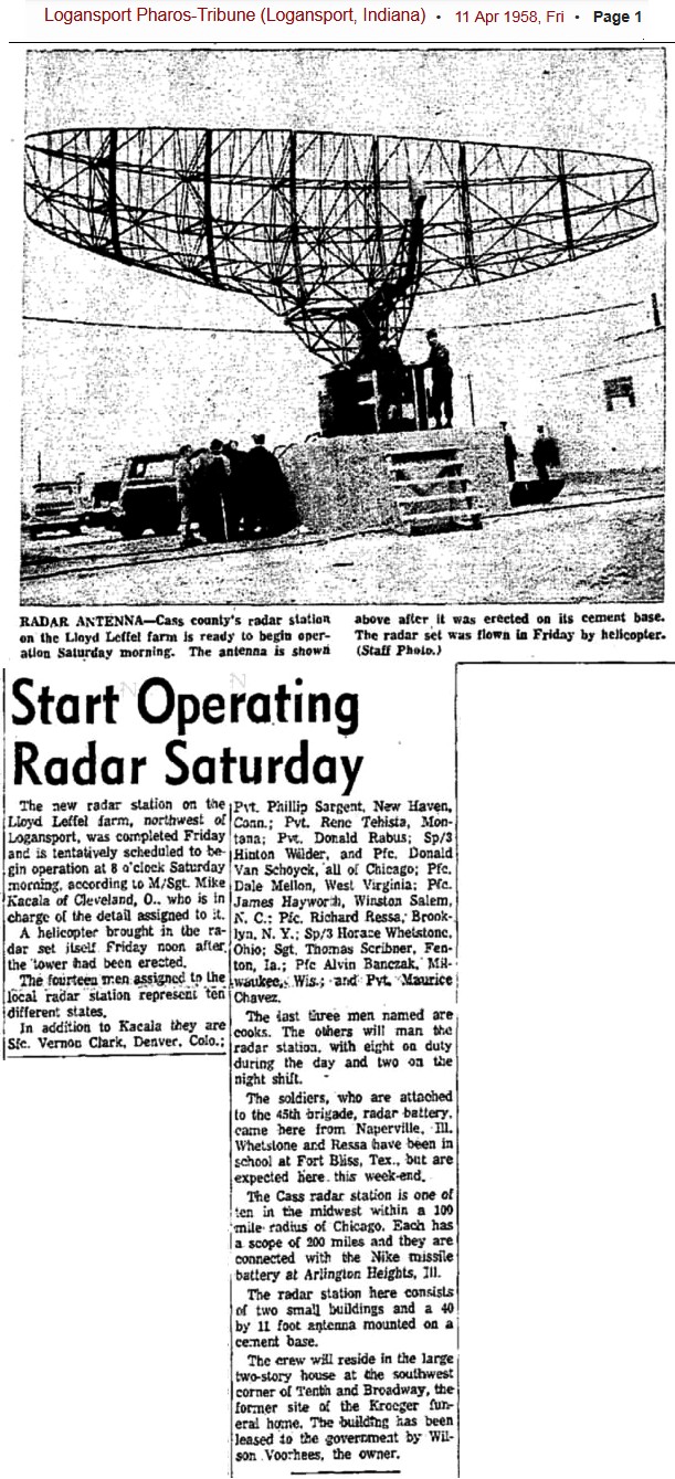
| CM-43R Logansport, MI (1)
| .
| .
| Newspaper article
found by Thomas Page
| From Mark Morgan, " I am guessing that the CM-43R radar emplacement was
somewhere near 40°46'48.55"N, 086°24'54.50"W. This location is about 2 miles
north of the river, just off US Rte 35. It looks like farm land. The topo map
shows it is on relatively high ground.
Ron Plante asks "Have we ever figured out why these sites were limited to Chicago? Could they be related to a Lake Michigan radar gap? " Thomas Page responded " I have heard that many of the Nike Defense Areas of the northeast had one or more early-warning radar sites like these (which the Army termed "gap-fillers"). I have heard that there were some of these Army "gap-filler radar sites also around New York City and Washington-Baltimore. Regarding the latter, reportedly there were Army "gap-filler radar sites at Fort Miles, DE; Fort AP Hill, VA; Fort Loudon, PA; and one (maybe) near Front Royal, VA. It appears that the Chicago-Milwaukee Defense Areas had the most because they were largest. Some sites were planned to become Air Force gap-fillers, but only a few ended up doing so. That's about all I know on the subject." In response to a quiry from Mark Foster,
After much dialog among Mark Foster, Mark Morgan, Thomas Page, Ron Plante, Scott Murdock, etc.
CM-48R Ludington, MI (2)
| .
| .
| .
| CM-50R Rossville, IL
| rossville,il. cm50r *
| .
| from Mike Abernethy - May 2005 -
We lucked out on Rossville. We talked to people who knew about the site, got copies of
newspaper articles, and found out that the grandchildren of the man who leased the property to
the government own the property. It was your "typical" radar site. And housing for the men
was at a house in town. We got a copy of a 1960 aerial photo of the site that is located at
| N 40-23-37; W 87-38-44. The structures were removed by the current owner's father prior to 1969 when the area was first farmed. It is currently agricultural -- nothing of the radar site remains. CM-55R Wenona, IL
| wenona,il cm55r *
|
Scott Murdock's report
| 41-03-22, 89-02-55
Picture found by Thomas Page
| He added an article (Mt. Vernon Register-News, 24 Sep 1959) that the 150 foot high slag heap upon which CM-55R was located was too unstable. (Cracking foundations and toppling the out-house. CM-62R Dixon, IL
| dixon,il. cm62r
| .
| from Mike Abernethy - May 2005 -
We then went to the County Recorder’s office to find out the current owners of the
property in question
get copies of the deeds. We then went back to the SCS Office and obtained copies of 1964 aerial photos
of the area
| 1.5 miles east of Hwy 26 (Section 35 and part of Section 36, T 21 N, R 9 E). We saw a few sites that may be something and traveled back to the area. We headed east on Hwy 30, North on Red Brick Road, and south on Walton Road onto the Book’s property. We continued onto their property to their farm and talked to Mr. Donald Book, his wife, and grandson about the Radar Site. Mr. Book removed the concrete two years ago. It was a very small site located in the middle of Section 35 on the north side of Hwy 30. There was only a 12’ x 12’ concrete base for the radar. It was about 1-2 feet thick, was not solid, but hollow in the middle. No other structures existed. He did not find any contaminants during the removal of the concrete. He remembered service men coming on the property in 1954 talking about building a radar site. The site was constructed in about 1955 and was discontinued just a few years later. CM-71R Argyle, WI
| .
| .
| from Thomas Page March 2019 -
| This spot is the previously-reported location for CM-71R, and this USGS aerial image supplements the ground-level views (one is also attached). The buildings are gone, but the concrete block that supported the radar antenna is clearly visible. The image date is 04-02-1961. The Lat-Lon coordinates are 42°45'24.35"N, 089°53'54.00"W. The image date is 04-02-1961. from Mike Abernethy - April 2005 - 4.2 miles NW of Argyle WI on Old Q and Saint Rds. , COORDS 42 45.411 89 53.896 The area is now an apple orchard but I did find the radar base and foundation or the control building. (see attached pics) ... gentleman at the tractor dealer, who sent me over to the city clerk who eventually lead me to Erma, one of the barmaids at the local tavern. Erma is a 60ish year old lady with tall blue hair who knew the "radar guys" well. The military converted a farmhouse into their living quarters about a mile from the radar site - it still stands. It was the location of many a wild party It seems they were very popular with the local girls. More than one girl got in trouble ( ie pregnant) by a radar guy. Several got married to local girls and still live in the area.. I plan to get some info from them later. CM-97R Princeton, WI (3)
| green lake,wis cm97r
| .
| from Mike Abernethy - April 2005 -
2.5 MILES SE OF PRINCETON WI, COORDS 43 49.841 89 04.874 | ... but most thought it was near the quarry on the intersection of highways 23 & 73. I drove out there – nothing obvious but thought where would I put a radar site. After wandering around the hilltops for an hour- I found it. It was the same as 2 other concrete radar bases I have seen, ( approx 12x12x12) but this one was pulled out of the ground and lying on its side. See attached pics |
Harold Cocherel served on the sites marked with an asterisk
Notes:
Sources
updated May 2005