Return to Home Page,
Return to Nike Location index
go to previous,
go to top,
go to next
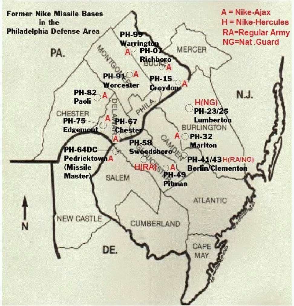
Locations of Former NIKE MISSILE SITES (text)
go to top
| PH-07 | Richboro
| web page Nike Base - PH07A,
Richboro, Bucks County, Pennsylvania By
Doug Crompton
C - 2 N Richboro, E of PA 232 ((P) Council Rock School District; offices
[{Gale, M} November 2002 - This one was the most fun.
First control 301 Twining Ford Rd. GPS 40-14-69, 74-59-93 {Drew Budwin noticed that the longitude should be
corrected to the current 74-59-93 - thanks } Still offices
for Council Rock School District. Several original buildings remain in use.
I found what appears to be 1 radar pad. ]
L - 1 E Richboro, N side PA 332 ((P) Northampton Tennis & Fitness Center)
[{Gale, M} November 2002 - Launch area is at 345 Newtown
Richboro Rd. GPS 40-13-66, 74-59-65 The magazines are intact, not filled in
both elevators intact. The township has erected baseball batting cages directly
over top between the elevators! Easy public photo op. ]
|
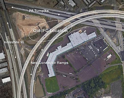
| PH-15 | Newportville
/ Croydon
|
K, William, [Jan 4, 2021]
This site is completely gone, the I95/PA Turnpike connector has been completed and all traces
of the PH-15 site have been erased. I attached a couple of photos of the location.
PH-15-IFC.jpg, PH-15-Control.jpg
----------
web site - new location as of July 2013
C - 0.5 W PA 413, S of I 276 ((O) private owner)
[{Crystal, W} [Feb 2009] The radar towers have been removed sometime late 2008, early 2009
and this site will be completely gone probably over the next 1-3 years. This area is going to become part of the long
awaited I-95/PA Turnpike connector ramps and roadways. (Now the homeless just have to be relocated.) ]
[{Gale, M} [2004] I would like to see you change
control from O to P as I personally saw 3 intact radar towers. Some
foundations of buildings remain but no other structures. Perimeter fence
remains also. The location could be enhanced to read "behind Bristol Plaza
Shopping Center, Durham Rd." ]
[(Murdock, S) GPS=40-07-40 074-53-14 ]
L - 0.5 W PA 413, S side Ford Rd ((P) USAR Center; 157th Bde (Separate)(Mech)
[{Gale, M} [2004] the street location could be
revised to" SW corner Ford Rd. and Pearl Buck Rd." (Still Army Reserve center)
The Magazines are paved over, no visible signs, now parking lot for Army
vehicles. ]
|
| Ft. Dix | SE Wrightstown
| Temporary site - (/55- /56)
Fort Dix: USAR/ArNG Regional Training Center
|
| PH-32 | Marlton
| C - 0.5 N Tomlinson Mill, Kettle Run Rd (O)
L - 0.8 NE Tomlinson Mill, N of Tomlinson Mill Rd (P) Evesham Board of Education
|
| PH-41/43
| Berlin/Clementon
| C - Williamstown Rd (P) Private owner
L - Cross Keys & Terlon Rds. N of Atlantic City Expressway (P) US Government, abandoned
|
| PH-49
| Pittman
| C - 1 WNW Pittman, Richwood Rd (P) Glouster County Christian School
L - Pittman-Jefferson Rd. (P) Kraemer Construction Company
|
| Ft. Mott
| Salem
| temporaty site
7 WNW Salem - currently Fort Mott State Park; wildlife refuge
|
| PH-58
| Swedesboro
|
[{Lewis,R} [April 2016] I?m working on the blog post for this site,
but there are photographs on my website and I will be adding a bunch more soon. Here is a link
to the photos on my site. There are also photographs of the Lumberton site and NY-56
http://richardlewisphotography.com/galleries/cold-war-nike-missile-sites/
The site is still intact, but the buildings are in bad shape with many collapsed roofs.
According to Woolwich Township officials the DOD which is still responsible for the Launcher
area and has plans to demolish everything above ground, although it is not known when that will
happen. The IFC is for sale by the township for redevelopment but there are no serious offers
on the table at this point. ]
C - 1 NNE Paulsboro Rd & US 322 (I) private owner
L -1.4 NNE, off Paulsboro (P) US Government?
|
| PH-64DC
| Pedricktown
| US 130, 2 NE Penns Grove - current USAR Center; 550th MI Battalion, Salem Community College
|
| PH-67 | Chester
/Village Green/
Media
|
C - PA 452, N of US 322 ((P) Penn Del County School District;
S. H. Smith Environmental Center)
[{Gale, M} [Feb 2005] I sadly confirm the status of PH-67 control
area as obliterated. Reconstruction of the school saw the remaining radar tower removed for
good. I got 1 last picture of some wires sticking out of the ground. The original buildings
were also razed in 2004. RIP ]
[{Gale, M} [2000] One IFC tower remains converted to some
kind of nature center. ]
L - N of Cherry Tree and Westchester Rds ((P)Chickester School Board /
Hilltop Elementary School
[ from Ed Cardow (June 2004) - The school district is thinking of utilizing the
launcher area, possibly as a parking lot, or building and was interested in the
long term stability - especially over the three elevators and ventilation shafts,
(now covered over with steel plate). They have a structural engineer on staff,
and will call the Army Corp of Engineers.]
[{Gale, M} [2000] Launch area is N of Cherry Tree and
Conchester Rds. The launch area is very visible under a very thin
layer of blacktop in the schoolyard. First time I actually stood on a
magazine today. Someone actually marked out one of the elevator locations on
the ground.
|
PH-75
(double) | Edgemont /
Delaware City
| web site
C - 1.2 W Castle Rock, N of PA 3 ((P) county road maintenance facility
[{Gale, M} [March 2000] IFC area is about to undergo
major change.
It previously went unchanged for years ( 3 towers remain, 2 buildings remain
totally overgrown and untouched) Well I went there 3 weeks ago to find much brush
clearing and cleanup and stakes in the ground as if the property may have changed
hands or something. ... is at the northeast corner of Pa. RT. 3 and Delchester RD.
and is visible from RT. 3.]
L - 1/2 W Castle Rock, S of PA 3 ((P) USAR Center; 157th Support Battalion
[{Gale, M} [March 2000] The launch area is clean
and orderly even though all entrances below ground are sealed with steel plates.
... in he Engineers complex at the southeast corner of Rt. 3 and Delchester Rd.
The magazines are not visible from the road as they are behind buildings on
the top of the hill.]
|
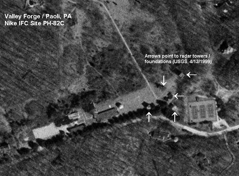
| PH-82 | Paoli /
Valley Forge
| Interesting document found by Thomas Page
C - 1 SW Valley Forge NHP, N of Yellow Springs Rd ((I) Univ. of Penn;
Valley Forge Research Center)
- IFC -
, TopoMap from the NikeSiteSearchers (12/04)
[{Innes, J} [1999] ...sold by the
University of Pennsylvania to a developer...]
[{Gale, M} [2000] Both IFC and Launch gone.]
L - near intersection of Wsedesford & Leboutillier Rds ((P) private owner)
[{Santangelo, R} Oct 2007 - Now there are expensive houses there. ]
[{Gale, M} [2000]Both IFC and Launch gone.]
[{Osgood, P} A housing development now stands on this site.
I was inside the site before it was demolished. Many of the buildings were
still standing. One building was filled with what appeared to be smashed
radar and other fire control equipment. The magazines were in good shape and
still had the elevator equipment in them.]
[(Murdock, S) GPS=40-03-52 075-28-53 ]
|
| PH-91 | Worcester
/Center Square
| Web page
C - S Worcester, Church Rd ((O) Worcester Nike Park)
[(Murdock, S) GPS=40-10-57, 75-21-00
L - Berks Rd ((P) USAR Center; 330 thh Combat Engineer Battalion
[(Murdock, S) GPS=40-10-52, 75-20-22
|
PH-99
(double) | Warrington
/Eureka
|
a web site
C - 2 NNW NAS Willow Grove, N side Folly Rd ((P) Warrington Township;
Igoe-Porter-Wellings Memorial Park, Twin Oaks Summer Camp
[{Buffington, J}
... township, has done a great job of developing
the fire control area into a memorial park, dedicated to the memory of three
enlisted men from there who were killed in Vietnam. The launch area has playground
equipment (active and passive recreation areas). ... I called the parks and recreation
department director at Warrington and told her that they did a great job of developing
the area ... but that one thing was missing: a marker making note of the fact that
over a period of several years, several thousand young men spent two or three years
out of their lives in defense of the area at the peak of the cold war. I pointed out
that the kids who used the facilities daily don't have a clue about what went on
there some forty years ago. For that matter, the youngsters think Nike means shoes,
shirts, caps and shorts.
The township government picked up on the idea immediately, and one supervisor has
advised me he is talking to the local historic commission about the marker. I am
researching the history of the unit, Btry B, 3d Missile Battalion (Nike-Hercules)
60th Artillery in order to write a brief history for them. ]
[{Carpenito, G} (12/2001) The marker mentioned in the
site info was dedicated in 2000 and is just off the parking lot at IPW park.
The Lower Nike Park is all but obliterated. It appears the fence line is
mostly intact but that's about it. Most of the back end of the park (where
I think the fire control radar was) has been bulldozed over. There is one place
where the entrance road splits that looks like it could have been one of the
magazines filled in and overgrown. ]
[{Gale, M} November 2002 - PH-99 control area has a
nice park as you know. The township people I met have more plans for Nike
awareness displays. GPS for control is 40-14-35, 75-10-10. ]
L - 2 NNW NAS Willow Grove, W side Folly Rd ((P) Warrington Township Lower Nike Site;
partially destroyed)
[(Murdock, S) GPS 40-14-20, 75-10-03 ]
[{Gale, M} November 2002 -
PH-99 launch area was being covered with fill the day I visited. The magazines
were partially visible but I suspect will be covered for good soon. I got some
photos. Only 1 structure remains in back, a small brick well pump house in the
woods. GPS for launch is 40-10-40,75-10-10. ]
|
| PI-02 | Rural Ridge
| C - S Rural Ridge, Rich Hill Rd ((P)Teen Challenge; drug & alcohol rehab
[(Murdock, S) GPS 40-34-16, 79-49-48
]
L - 0.4 N Rural Ridg ((P) Penna. Dept. of Transportation; road equipment yard
[anonymous, 7/99, "The owner of the old west penn airport is planing on buying
the launch area to extand his runway"]
[{Gamerro, R} (Nov 1999)... the site being sold to the neighboring airport is
true, but it may be a few years until it is realized. We have remodeled the
old barracks building and use it as our offices and classrooms. The three
launch silos are still intact and empty.]
[(Murdock, S) GPS 40-35-48, 79-49-21
] |
| PI-03 | Dorseyville
/Indianola
|
15 miles N.E. Pittsburgh on Route 910 in West Deer Township
C - Saxonburg Blvd ((I) American Indian Center Singing Winds Site)
[(Murdock, S) GPS 40-34-50, 79-53-43 ]
[{Linhart, B} (April 2001) The Fire control site
is still part of the Three Rivers American Indian Council and is in good condition. ]
L - 1.3 N Dorseyville ((I) Northwest Deer Township Senior Citizens Center
[(Murdock, S) GPS 40-35-54, 79-53-31 ]
[{Stapleton, M} [Jan 2015] has an open hatch
and is partially full of warm water.
[{Hashash, B} very complete w.r.t. buildings, fences, etc.]
[{Linhart, B}[May 2000]Our soccer club has built two fields at
the former launch site of PI-03. Ironically the name of our club is IFC for
International Football Club. The site is overgrown but appears pretty much intact.
The origonal barracks is now a Community Center. Metal doors cover the magazines but
all the underground facilities are filled with water. During the winter the Warhead
building and Assembly building are used for storage of Picnic Tables.
(April 2001) West Deer Township has started the destruction this week of
all the above ground hardware on the launch pad. The blue electrical switches
and semi circular hose holders are being cut off at the ground surface along
with some pipes.. The IFC Soccer Club completed one soccer field and is about
to seed the second one. Both are adjacent to the launch magazines.
The township manager is Shelia Hanlon. The number at West Deer is 1-724-265-3680.
I don't know if any of the hardware is of value to a restoration project. ]
|
| PI-25 | Murrysville
/Monroe[ville]
| C - 713 New Texas Rd ((P) Univ. Pittsburgh Primate Research Lab)
[(Marak, R) August 2009 - The site is located in Plum, PA, quite near
where the borders of Monroeville (not Monroe, located in the opposite
end of the state), Plum & Murrysville meet. I drive past it all the
time. When I was a kid, you could see the missles on the hill across
the valley from the lot at the end of my street in Monroeville.
The army housing is still present on the site and is rented out to
tenants; there was a rental sign indicating units available when I drove
past earlier this week. I don't know if any of the other facilities are
still in place. Everything's pretty overgrown and you can't really tell
from the road. ... ]
[(Darrall, M) Both sites are actually in Plum Borough,
northeast of Pittsburgh and immediately north of the borough of Monroeville.
Murrysville is a town east of Monroeville and southeast of Plum.
The New Texas Road site is closest to what used to be the village of Unity.
Whether that appears on any maps or not is beyond me. ]
L - 428 Presque Ile Rd ((O) A.E. O'Block Elementary School, A.E. Stevenson High
School)
[(Darrall, M) The names of the two schools at
Presque Isle Drive are A.E. O'Block Junior High, and Adlai Stevenson Elementary
School. ]
|
| PI-36 | Irwin
| C - 1 NNE North Irwin, 1600 block Morris Rd ((P) Norwin Soccor Club,
Norwin YMCA, Oak Hollow Seniors Center)
[(Murdock, S) GPS=40-20-42 79-41-57 ]
[(Jones, Donnie Jr) Oct 27, 2018 -
Across the turnpike where the command and control center was everything is pretty much
still intact including the block house with bomb door still intact inside of the
snack bldg that is attached to it ! ]
L - 2 NW Manor, W of South Sandy Hill Rd, End of Nike Rd. ((P) private)
[(Murdock, S) GPS=40-20-46 79-41-04 ]
[(Jones, Donnie Jr) Oct 27, 2018 -
My father, Donald Jones, worked at Irwin base and Oakdale command. (pictures) -
I travel up there to Irwin sometimes to remember him ...as a kid I ran around on that base when i went
on weekends. I am just emailing you to let you know that the launch site has totally been destroyed and gone !
A homebuilder purchased the site
and I?m not sure if the missle storage areas where imploded...but ,what?s funny is I distinctly
remember where all the missile storage areas were and they build homes over them !!!
I?m sad that that base is gone and ....there?s no remnants of it other than the fence next
to the road where the base began and you can still see remnants of the guard house and the
electrical switch on the telephone pole that I believe electrified the fence? And the road is still named NIKE road . }
|
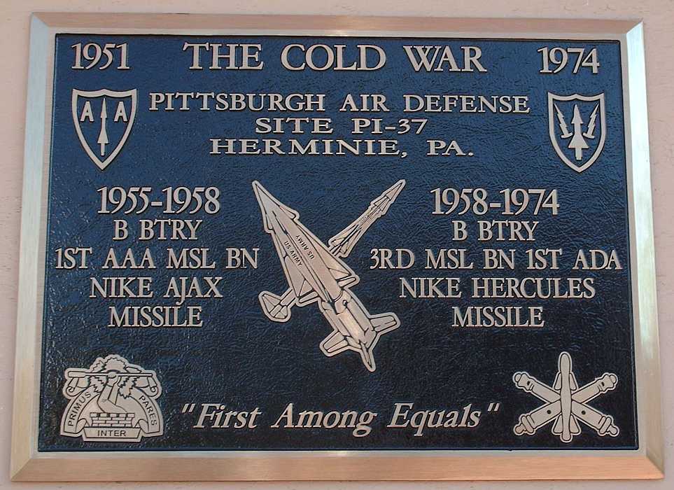
| PI-37 | Cowansburg
/Hermine
web site

|
Donald Wellman sent the image of the
plaque "dedicated during our August 2011 Reunion."
and this
link to newspaper coverage. "The newspaper article has some basic facts wrong, but it seems that reporters seem to have trouble relaying the facts nowadays!!!"
C - 2 NNW Herminie ((?) abandoned)
[{Hashash, B}"Gutted"]
[(Murdock, S) GPS=40-16-22 79-45-49
]
L - 2.5 NW Herminie ((I) Private)
[{Hashash, B}The launch site is occupied by a
machine shop. The owner
drained and refurbished one of the magazines and uses the elevator to access tools
and whatnot he has stored below. Definately had nuclear capability, with kennels
and a blockhouse that I have not seen on other sites.]
[(Murdock, S) GPS=40-15-46 79-45-55
] |
| PI-42 | Elizabeth
| C - 1 E Hillsdale, W of PA 48 ((P) Elizabeth Forward School District
[(Murdock, S) GPS= 40-15-01 79-51-27
]
L - 1 W Mustard, N of Pineview Rd ((I) Twin Pines Council of Governments Police
Firing Range)
[{George R}housing for NIKE Site is located across the
street from the IFC and is private housing.]
[(Murdock, S) GPS 40-13-54 79-50-12
]
Housing -
[(Murdock, S) GPS 40-14-57 79-51-20 ]
|
| PI-43 | Elrama
| C - 1.3 W Elrama ((P) PAArNG; D/876th Engineer Battalion)
[(Murdock, S) GPS 40-15-08, 79-57-07 ]
L - 2.2 W Elrama ((I) PAArNG; B/1/110th Infantry)
[(Murdock, S) GPS 40-15-15, 79-57-59,
Hsg, 40-15-00, 79-57-58 ]
[{George R} ... is abandoned. The Army Reserve and National Guard
pulled out of the Launch and Control sites a few months ago. (1998) ]
|
| PI-52 | Finleyville
| C - 1.2 S Finleyville, Finleyville Rd ((P) South Hills Christian School
[{Morgan, M} 1992 - PI-52C is on the ridge to the north,
fairly intact and was serving as the South Hills Christian School.
I went up on the knoll behind the buildings and didn't find any evidence
of the radar palts, but did get a good view of Allegheny VORTAC on the next ridge over.]
L - 2 S Finleyville, Finleyville Rd ((P)Walter Long Manufacturing Company)
[{Morgan, M} 1992 - The launcher was
across Finleyville Road on another ridge; the occupants included a church and
the Walter Long Manufacturing Company. The buildings were all there and the
launcher section had some manufacturing buildings at one end. ]
[{Lesky, M} The housing has been civilianized,
all 6 or 7 houses. the rest of the living quarters are gone. the launch sites
are still fenced in and looks like it's kept up. That is alot of grass to cut.
there is 1 building close to the road and off in the distance you can see the
business end of the site. ] |
| PI-62 | Bridgeville
/Bryant
| C - 1 ESE Oakdale, Oakdale & Thoms Run Rds ((P) USAR; motor pool)
[(Murdock, S) GPS 40-23-35, 80-09-59 ]
L - 2 SE Oakdale, S side Battle Ridge Rd ((P) US Army Support Facility)
[(Murdock, S) GPS 40-23-10, 80-08-20 ]
[{Mandeville, P}site is intact ... . All buildings are in use by
Oakdale support facility .
The launch area still is surrounded by a fence and all missle pits are still
there, but welded shut. Stairways leading to the missile storage area are
locked.]
A - ((P) Headquarters, Army Readiness Group, Pittsburgh) |
| PI-70DC AADB | Oakdale
| 2 E Oakdale, Thoms Run Rd (USAR Charles E. Kelly Support Center;
various military, FAA radar site)
[Binder, {Michael} Nov 29, 2012
"Collier to get a brewery at former Nike missile site" ]
[{Page, T} Nov 29, 2012 ... It is the most-intact of all the former air-defense radar stations
in the Lower 48 of the Cold War era. All but one of the original radar towers are still standing.
And one radar there is still in use today.
... Oakdale had additional significance with respect to the usual, garden-variety radar site.
That is, it was a joint-use radar station for three government agencies: the U.S. Air Force, the U.S. Army, and the FAA.
For the U.S. Air Force, the Oakdale radar site was one part of its Air Defense Command's nationwide coverage.
The attending 662nd Radar Squadron actually began service at Brooksfield AFS in eastern Ohio; the squadron was
relocated to Oakdale in the early 1960s specifically to maintain and operate the radars for the Army's Nike
"Missile Master" command & control facility there. The Air Force's own Operations building and a few others
are still in place.
For the U.S. Army, the Oakdale radar site was the eyes and ears of the Pittsburgh Defense Area. The radars
there at Oakdale provided the long-range radar detection for the Nike missile batteries around Pittsburgh.
The aforementioned Army's Nike "Missile Master" command & control center is still intact (only ten such MM
facilities were ever built, and only about half are still extant today).
For the FAA, the Oakdale radar site was (and still is) one of many long-range air-route surveillance radar
sites all across the country. From day one, the FAA maintained and operated the search radar at Oakdale
(first their own ARSR-1 model, then later the Air Force's AN/FPS-24 model plus a backup AN/FPS-20 model
on the next hill). (The Air Force maintained all the height-finder radars.) The FAA now operates an
AN/FPS-67B radar (atop the old AN/FPS-24 radar tower), so to be replaced by a modern CARSR radar.
For more information, please see
http://www.radomes.org/museum/showsite.php?site=Oakdale+AI,+PA&squadron=&country=.
Scroll down, and click on "Photographs" or "Recent Photos" or any other link of choice. ]
[{Laughlin, K} former
Missile Master base at Oakdale, PA (99th ARCOM) is going to be deactivated,
site will be turned over to various Allegheny county departments ] |
| PI-71 | Corapolis
/Beacon
|
C - Silver Ln, NNW of Forest Grove ((I) Robinson Dept. of Public Works)
[{Murdock, S}GPS=40-28-53, 80-08-42
TopoZone (Overall view; IFC to right, launcher to left) ]
L - Nike Rd ((P) private owner)[{Hashash, B}Demolished]
[{Murdock, S}GPS=40-29-03, 80-09-54 ] |
| PI-92 | Bryant
/North Park
| C - 2 NE Highland, Peebles Rd ((P) USAR North Hills Army Reserve Center;
128th Military Intellengence Battalion (CEWI), 446th Military
Intellengence Battalion det)
[(Murdock, S) GPS 40-34-34, 80-00-05 ]
L - 3 NE Highland, Kummer Rd ((I) Allegheny County Police & Fire Academy)
[(Skertich, R) (corrected above, and)
The current address is West Ridge Drive.
I'm a part time instructor at the fire academy.
One of the other instructors was a federal civil servant at the site
while it was an active site. He has some interesting stories.
The silos are used for various fire and police training activities.
FYI ... the academy website is
http://www.county.allegheny.pa.us/emerserv/fireacad/index.asp
[(Murdock, S) GPS 40-35-27, 80-00-33 ] |
| PI-93 | West View
| C - 0.8 NW West View, Gass Rd
[{Harris, W} July 2010 - In my capacity as a Cable
Splicing Tech for Verizon, I frequently have access to Westview PI-93.
The site is largely intact, with the addition of two cell towers and a Army
Corps of Engineers building. The USACE site is a communications site and
has a large HF antenna associated with it. ]
[{Foster, M} July 2010 - Upon further ... of the 57
and 64 Historicaerials it appears all of the barracks and administration buildings
were at the Control Area, just up Jake Bron Road. ]
[{Koedel, T} July 2010 - In 2008, the Guard unit was transferred to Grove City, PA.
This site is currently occupied by the United States Army Corps of Engineers for use as a communications hub
for their Locks and Dams in Pennsylvania and Ohio. ]
[{Poole, R} Jan 2007 - Gass Road, not Bass Road,
{Ah Ha - Rings of Supersonic Steel is not
purrfekt ;-| fixed - thanks} and it is still in use
by the army as a signal battalion of some sort. ]
[{Hashash, B} Near Camp Horne Road exit of I-279.]
((P) PAArNG, 28th Signal Battalion)
[(Murdock, S) GPS 40-31-39, 80-03-45 ]
L - 1.3 NNE Emsworth ((P) Avonworth High School)
[{Poole, R} Jan 2007 - When the site was closed down in 1970's, Ryan
Homes bought the launch site and built a housing plan there. It was long rumored that one of the houses was built overtop one of the
missile bays and has it as a basement. I had heard this rumor from many people over the years and, many years later, ran into some
people who lived across the street from this house in the plan. They confirmed that the house in question did, indeed, have the old launch
bay as its basement. I have never seen this myself, but I believe this to be true based on several accounts and the direct confirmation
from the neighbors. ]
[{Hashash, B}Launch site demolished] |
go to top
Return to Home Page,
Return to Nike Location index
go to previous,
go to top,
go to next
If you have comments or suggestions, Send e-mail
to Ed Thelen
Updated Jan 4, 2021