| FORT STRONG (B-35R) FORT DAWES
(B-22) |
 |
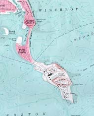
Boston Harbor and its many islands were the home to numerous forts and strongholds during the coast artillery era. Two of these, Fort Dawes, on the end of Deer Island, and Fort Strong, on the end of Long Island, were used by the Nike program. Fort Dawes was an Ajax installation in the early days of the program, at which was also still located a gun antiaircraft artillery battery. Fort Strong, with its central location, held a Nike radar installation for a short period. Both sites were only short boat rides from downtown Boston.
 |
 |
 |
|
Fort Duvall |
Street Map of Site |
Fort Strong |
| Location Fort Strong- northern end of Long Island, Boston Harbor;also located on Long Island was the launcher site for Quincy/Squantum Site B-37. Long Island is connected to the mainland (Moon Island/Squantum) via a bridge. Fort Dawes- southern end of Deer Island, Boston Harbor. Deer Island is no longer an island, being connected to the town of Winthrop by landfill. The former waterway, Shirley Gut, was used by the British ship HMS Shannon, as a hiding place in 1814 in its famous duel with USS Chesapeake. Present Status Fort Strong is in ruins including the old lighthouse. Fort Dawes is part of a complex that includes a prison and water treatment plant. Links Long Island http://www.tiac.net/users/fbhi/longisland.html Deer Island http://www.tiac.net/users/fbhi/deer.html Contacts Pictures |
Dates of Operation Fort Strong 1958-1961 Fort Dawes 1956-1957 History
|
|
| Next Site | Previous Site | Site List | Unit List | Home | This Page Last Updated: Wednesday, August 18, 1999 |
|